Geographic Information Systems
Advertisement
HEC-EFM v.2.0.0003
HEC-EFM analyses involve: 1) statistical analyses of relationships between hydrology and ecology, 2) hydraulic modeling, and 3) use of Geographic Information Systems (GIS) to display results and other relevant spatial data.
Advertisement
GeoSurveillance v.1 1
GeoSurveillance is software that combines spatial statistical routines with some basic Geographic Information Systems (GIS) functions to carry out retrospective and prospective statistical tests for the detection of geographic clustering.
Mapnik v.25.26
Mapnik is an OpenSource C++/Python toolkit for developing GIS (Geographic Information Systems) applications.

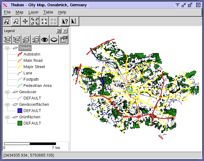
Thuban for Linux v.1.2.2
Thuban is an interactive geographic data viewer (GIS viewer) which features methods to visualize, explore, and analyze geographic information.
Thuban for Mac OS X 1.0.1-3 v.3
Thuban is an interactive geographic data viewer (GIS viewer) which features methods to visualize, explore, and analyze geographic information.
Thuban for Windows v.1.2.2
Thuban is an interactive geographic data viewer (GIS viewer) which features methods to visualize, explore, and analyze geographic information.
UCertify CISSP - CISSP practice test
Pass CISSP exam CISSP in first attempt. 561 questions with detailed explanation and 276 study notes. CISSP - Certified Information Systems Security Professional study notes, articles and mock test. 99% pass rate, 100% money back guarantee. Based on latest
GIS ObjectLand v.2. 6. 2003
GIS ObjectLand is a universal Geographic Information System for Windows. Key features: - creation of vector-raster maps with arbitrary structure of layers and feature types; - creation of themes. Theme is a user presentation of a map; - control of
Geisom Professional v.1.5
Geisom is a geographic information system (gis) used to easily access complex geographical information.
ArcExplorer v.4.0.1
ArcExplorer is a lightweight GIS data viewer developed by ESRI.
Distributed Information System (NZDIS) v.1.0
New Zealand Distributed Information Systems (NZDIS)Distributed, heterogenous, agent-based framework for intelligent/semantic information and services integration.